


Rando Les Clées

TRIMAILLE
User
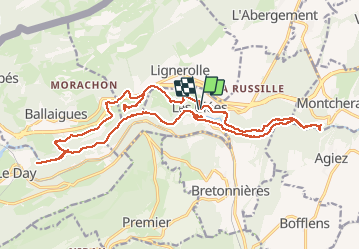

Length
24 km

Max alt
808 m

Uphill gradient
772 m
Km-Effort
34 km

Min alt
529 m

Downhill gradient
769 m
Boucle
Yes
Creation date :
2019-11-27 17:25:13.487
Updated on :
2019-12-11 11:09:05.665
7h08
Difficulty : Difficult

FREE GPS app for hiking
 SityTrail
IGN / Geographical institutes
SityTrail Plus
The world is yours!
About
Trail Walking of 24 km to be discovered at Vaud, District du Jura-Nord vaudois, Les Clées. This trail is proposed by TRIMAILLE.
Positioning
Country:
Switzerland
Region :
Vaud
Department/Province :
District du Jura-Nord vaudois
Municipality :
Les Clées
Location:
Unknown
Start:(Dec)
Start:(UTM)
306167 ; 5178469 (32T) N.
Comments